| Previous |
Next |
G'day (hello). How ya goin', mate (how are you)?
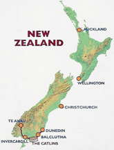
At this moment we are onboard the ferry crossing the Cook Strait from South Island to North Island, New Zealand. This is our second trip to NZ and it almost feels like coming home. Seven years ago, we visited many of the major tourist areas. This trip we have two goals: one is to be able to ski NZ (it is spring here). The other goal is to explore some parts of NZ that may be well known to the Kiwis (what NZers call themselves), but are far less traveled by fearless (or clueless) foreigners in small rental cars. First, a few facts about NZ.
Q: How about a quick geography/history/politics lesson?
A: NZ is about 1500 km (900 mi) east of Australia. It consists of two major islands that have (as the guidebook states) "hairline fiords and glacier-weighted mountains in the south, rolling green hills fringed with golden beaches in the north and abundant volcanic activity producing geysers and natural hot pools [Rough Guide to NZ]". The South Island has multiple ranges of mountains (called the Southern Alps) running up the spine, caused by the collision of two continental plates. This means occasional earthquakes and rockslides. It also means incredible scenic views on narrow winding (and windy) roads. (We'll talk about the North Island in the next e-postcard).
The Maori (pronounced "morry") is the general name given to the original native tribes. They called NZ "Aotearoa", the land of the long white cloud. They were known as a fierce people with a strong tradition of tattooing their faces and body to intimidate their enemies and record their accomplishments. The people fished, farmed, and hunted, although not always wisely. An ostrich-sized bird, the moa, was wiped out by the Maori for its meat and feathers. The Maori were constantly warring with each other, but found a common foe when the Europeans (mostly British) arrived. The British eventually overwhelmed the Maori. The 1840 Treaty of Waitangi ceded NZ to Britain while supposedly guaranteeing land and fishing rights to the Maori. Of course, the treaty was virtually ignored by the British as they colonized NZ. However, the Maori were able to keep some of the tribal traditions intact. In 1997, the NZ government issued a formal apology to the Maori, restoring some land rights and traditions. As a result, you see dual language signs for government buildings, street signs, and many historic/scenic areas. Also, unlike the U.S. and Australia, the natives were not forced to move to reservations, and remain dispersed throughout the country.
Like Australia, NZ is part of the British Commonwealth and a representative democracy. NZ is not to be confused or connected with Australia. The Kiwis consider themselves more politically independent and ecologically minded than the Aussies. The national sport is rugby (kind of like American football) and the whole country is quite vocal in support of the NZ team, the All Blacks. Instead of having two team colors (like maize and blue for U of M), they just use black. Before each game, the team performs a Maori chant accompanied by intimidating movements (called the haka) - the crowds chant along. A commonly seen t-shirt proclaims, "I have two favorite teams - New Zealand and anyone who beats Australia".
Q: What are the prominent features of the South Island?
A: As you gaze out the window you can see snow-topped mountains, sheep, fertile valleys with farms (of kiwi, apples, olives, hops for beer), lambs, glaciers, sheep, streams and rivers filled with trout and salmon, sheep, cattle and an occasional goat or llama, sheep, temporary waterfalls resulting from thunderstorms in the mountains, sheep, wineries with grape vines nestled into steep hillsides, lambs, rainforests, and, of course, sheep.
And this can be all in one day! The official count is 14 sheep per NZ resident but as we are in the midst of lambing season, either the count is off or a lot of people have deserted the country.
Q: Any interesting things to eat?
A: This is a land of great fish and chips (french fries). The chips come in a poddle (or small cup) or scoop (what they dump in paper before it is wrapped). NZers are very creative in developing potato chip flavors, which include lime/pepper, chili, Thai chicken, chicken satay, ham/Dijon mustard, and (believe it or not) lamb/mint jelly. (We haven't had the inclination or stomach to try the last one). Pumpkin is most commonly used in delicious soups and in stir frys. Kumara (sweet potatoes) are eaten sliced on sandwiches with beef or lamb or as a side dish. Scrumpy cider is a wonderful bubbly apple cider with 8% alcohol content. There are also local wines (mostly white in the South Island, reds in the North Island), gourmet olive oils, organic salami, goat/sheep cheeses, and many microbreweries. The seafood, as one would expect, is glorious. This includes green-lipped mussels (the shell is green, not the mussel), smoked salmon, Dunedin clams, and the other stuff we can't identify in delicious seafood chowder. And, of course, lamb - minced (ground), chops, in burgers, and stews. Actually, we haven't eaten everything listed above but we are working on it - except the lamb potato chips!
Q: What have you been doing?
A: Although we have resisted up to now giving you a day-to-day list, we would like to write about our South Island adventures by region.
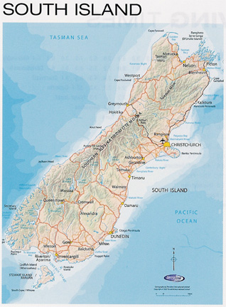
Christchurch: The trip from the Cook Islands started by waking up at 1:15 a.m. to get our luggage to the airport by 3 a.m. for the 4 a.m. flight to Auckland (NZ's capital in the North Island) and the 10 a.m. transfer to Christchurch in the south. We arrived early in Christchurch, finding the weather very windy and sunny but about 40 degrees. Our luggage, however, was still on "island time" and, upon hearing the NZ weather report, decided to stay in the Cooks. It took 30 hours and numerous calls to locate the luggage and persuade it to join us. NZ Airlines policy allowed us to buy some necessities until the luggage arrived. This included a jacket, some sweaters, gloves and a hat (most of which was still in the Cooks, being useless).
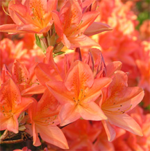
We stayed at a familiar hostel, Rolleston House, located near downtown, the art center, and the botanical garden. Christchurch is a pleasant combination of contemporary city with an old English flavor, easy to walk about. Punts (small boats like the gondolas of Venice) are pushed along the Avon River. The rhododendron and azaleas are in full bloom. Spring is in the air despite the temperature. However, Tim would like to catch the end of spring skiing so we are traveling south, to the mountains.
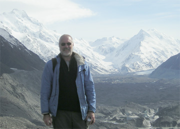
Mt. Cook: Tentative plans were to ski Mt. Hutt on our way to Mt. Cook National Park. The snow was fresh, the temperature right, but unfortunately high winds forced the ski field to close. (To the locals, Mt.Hutt is known as Mt. Shut!). There is still potential skiing down south so we drive on to Mt. Cook.
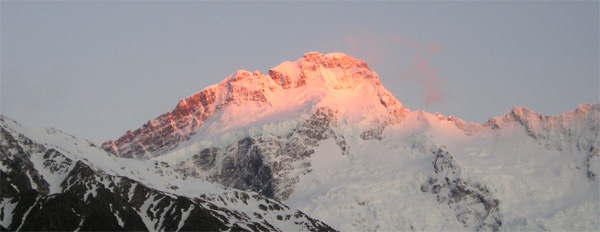
Mt. Cook (aka Aoraki, the cloud piercer) is the highest mountain in NZ. We had visited here before and enjoyed it so much we had to return. The hostel is in a valley surrounded on three sides by mountains. There are numerous hikes nearby ranging from one hour to several days in length. The previous day had been cold and rainy. Fortunately, we woke up to clear skies. Despite the continuing cold wind, we bundled up, packed a lunch, and tackled a few trails. We got up early enough to be on the trail before 8 a.m. By early afternoon we had hiked three trails (in 4.5 hours) which included a sighting of the rare Mt. Cook lily, the sun rising in the mountains, and crossing (in both directions) two swinging bridges over rain-swelled rivers in 40 mph winds (the adrenaline was flowing then). The trails ranged from being blacktopped to gravel to rocks and always had more uphill than downhill (how is that possible?). The advantage of being early in the day and traveling in the spring is that we had the trails and the magnificent views to ourselves much of the time. Another advantage is that we could return to the hostel for a well-deserved (and necessary) nap. Although we both did multi-day backpacking trips in our youth (and Tim's sister Sally still does), we prefer the comfort of a real bed at night! That night there was a thunderstorm (how loud it sounds echoing in the mountains!), 60 mph winds, and a light coat of snow on the car.
Thank goodness for digital cameras - when you get back to the hostel after a hike and realize you've taken far too many shots of the same mountain, you can delete most of them. (Just a note, at the halfway mark on the trip we have 1500 photos "good" saved, so be careful if you ask us to see pix of the trip).
Dunedin and the Otago: The next phase of the itinerary took us to unknown territory, the southeastern and southern coast (known as the "Deep South" here). Nature's forces continually displayed themselves in rugged cliffs intermixed with sandy beaches. The region is called Otago and a major source of a special white limestone that was (and still is) used on buildings throughout NZ. This stone, called "free stone" is soft when first mined and easily carved, then hardens with age, making it perfect for the intricate carvings seen on churches and official buildings. Otago was also the starting location for the NZ gold rush, which began in 1861. Many of the miners had California experience and were still looking for that "big strike". The Otago area is littered with the remains of small towns and mines, which boomed for 2 - 3 years until abandoned for the next goldfield.
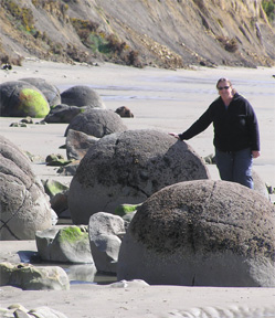
On the way southeast were the Moeraki Boulders, round rock formations several feet high that are uncovered as surrounding sand wears away. The otherwise bare beach looked like a giant's game of marbles. Dunedin, the area's largest town is spread over many hills surrounding a narrow bay. In fact, they claim the world's steepest street (Baldwin) with a slope of 19 degrees. Although we didn't walk Baldwin, it sure felt like it as we walked home from the local brewery tour. We stayed here in an attic room overlooking the city. Our hostel was a former small private hospital with lots of small rooms and three ghosts (so they say).
The Catlins: At the very southern tip of the South Island is a desolate, sparsely populated, wild area called the Catlins. The soil is poor so land is barren or used for cattle ranching (or a few sheep, naturally). A series of nationwide beer commercials popularized the men of the Catlins area as "southern men" - hard living, hard riding, hard drinking cowboys. We didn't see any cowboys, but Di saw a guy rounding up his sheep while driving a John Deer tractor.
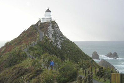
Just a few years ago, the main road through the Catlins was completely paved. Although it hasn't yet brought crowds of tourists, the improved roads allowed us to see some things difficult to reach previously. After a long drive on an unimproved road (called "loose metal") and a cold, windy cliffside walk we reached the lighthouse at Nugget Point (440 feet up). The name comes from the nugget-shaped black stones strewn on the lighter sand beach and hillside. It is next to Roaring Point, named for the loud rush of Antarctic-born waves against the rocks. This is the world's only mainland breeding ground for elephant seals and a gathering site for many sea birds. I think they were all vacationing in better weather, as there was not an animal to be seen - but a great view, otherwise. We did, however, see a rare, lone Nugget Point daisy plant, blossoming in the inhospitable conditions.
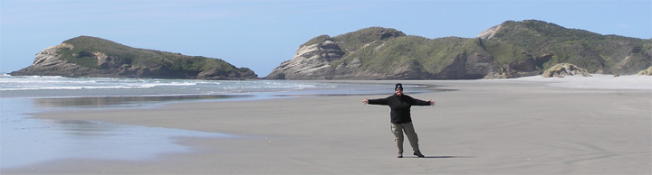
The weather had been variable that day with alternating sun, rain, clouds, and cold wind. We visited other Catlin natural features including a waterfall walk, a boardwalk through an estuary, and Curio Bay (the southernmost point on South Island) with raincoats readily available. Curio Bay had been a forest thousands of years ago and is now a large collection of petrified trees, strewn upon a rocky beach. A few photos into our visit, we ran for the car....it was hailing! An appropriate ending to our Deep South visit.
Te Anau and Queenstown: A quick visit to Te Anau (gateway to the fiords) brought us back north. We had taken a plane/boat trip to the famous Milford Sound on our previous trip. This area of NZ is all mountains, lakes, and the Tasman Sea. At the southwestern coast, the sea creeps between glacial rifts in huge mountains to create narrow passages, here called fiords or sounds. Only Milford in accessible by car, the rest by plane or hiking. Te Anau, at the base of a huge lake, is the starting/ending points for these trips. It was a good place to stop after all the driving Tim did in the Catlins.
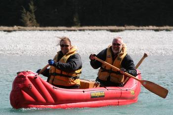
The next four days were spent in Queenstown, the outdoor sports capital of NZ. Since weather had been unpredictable so far, we immediately booked a couple of water activities (cancelable). To get our paddling skills up to speed, we spent the day on the nearby Dart River. After a short drive to the river, 11 of us (plus two guides) were outfitted in two fleece shirts, full wetsuits, neoprene socks and boots, rain gear and life jackets. Di looked like a waterproof Michelin man. After an hour speeding upstream in a jet boat (and doing fast 360 degree turns guaranteed to get the guys in the back (us) wet and a short paddling lesson, we got into our Funyak, a two-person inflatable canoe. The wind was against us, the river water was cold but with the help of the current, some hard paddling, and excellent direction from the Funyak captain (Tim) we went downstream without disaster. The river wound though incredible scenery including surrounding cliffs, waterfalls, old gold mines (with rusting equipment), and a small hidden gorge. And that was all before lunch on the riverside! The rest of the day was finishing the trip and attempting to pull off all the layers of clothing (all of which, in hindsight, were essential). For you Lord of the Rings (LOR) fans, we saw where some of the key movie scenes were filmed while we were paddling. They included where Gandalf rode the white horse across the grassy plains, the elfin domain of Lothlorien, and Isengard, the White Wizard's Tower.
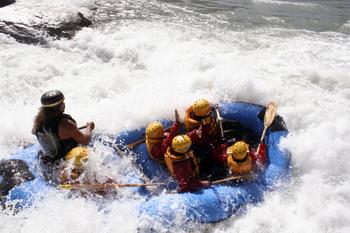
Now that the arm muscles were loosened, we headed out the next morning for white water rafting on the Shotover River. We have been looking forward to this since our last NZ trip. Then we tried to do the Shotover but were moved to another river since the water was too low. Not a problem this time. We started with a bus trip to rafting starting point, where we put on a fleece top, wet suit, booties, rain jacket, life jacket (does this sound familiar?) and a helmet. The helmet and the very thorough paddling/floating lesson let you know this "ain't no Funyak". What a rush this trip was! The inflatable raft holds six tourists and a guide. On previous white water trips, you can easily get stuck with people who can't or don't paddle or who panic when they see the white water. This time we had only five of us (all willing workers) and an incredible experienced guide, resulting in great teamwork, a wild ride, and no one falling out (always a plus when the water is cold). In whitewater rafting, the best/worst place to sit is up front. You get the best view of the upcoming rapids and the most wet as you hit them - you guessed it, we were put (not volunteers) up front. The trip was a combination of some (too) short easy floats, frantic paddling against the wind, and even more frantic paddling to hit those white water rapids just right. The best part was through an old 200 meter long mining tunnel that ended in a short but big rapids. Di swallowed a lot of unexpected water on that one (see attachment). Exhausted but exhilarated, we peeled off the many layers and went home for a nap.
Wananka and the Glaciers: Next stop was Wanaka, a small town next to the Mt. Aspiring National Park. This was a short stop on our way to the glaciers. Mt. Aspiring may have been inspiring, but we were unable to see it due to clouds. (LOR note: We now know why this area was chosen for the Misty Mountains in the film). However, we did visit a local winery, which is following the bio-dynamic system. I guess this is a hot topic among vineyards and farms throughout NZ. It follows organic principles of using only natural fertilizers and pesticides, but requires planting, harvesting, etc. to be done based on phases of the moon. This sounds a lot like the Farmer's Almanac method, but the vintner has claimed it has been successful for all kinds of crops and gardens.
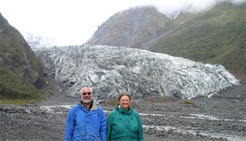
A very long drive to the glaciers was broken up by a short walk that has made it to our top 10. This trail had all of Di's favorites: rainforest, swinging bridge, boardwalk, mountains, and water - in this case, some beautiful blue/green pools. More driving through winding roads brought us to the two most accessible glaciers in NZ, Fox and Franz Josef. In both cases, you can walk alongside the glacial river with the blue/white glacier in full view and feel the temperature decrease as you approach. Since the glacier and its runoff paths change daily, the trail to the glacier is often rocky with the occasional small streams to ford. You are not supposed to go within touching distance of the glacier without a guide as ice could collapse on you at any time. We had been that close before, but this time the streams prevented easy access. The sight of these mighty ice rivers is unforgettable. Franz Josef glacier is special as a half hour walk takes you from glacier to subtropical rainforest.
The West Coast and the Top of the South: The last region to cover in the South Island was the northwest corner, home of Abel Tasman National Park and Farewell Spit (named by Captain Cook as he headed out to sea). The ride up the west coast from the glaciers was long with only a tourist stop at the Pancake Rocks, seaside rocks worn to look like huge piles of thin pancakes (actually, more like crepes). It sounds touristy, but the rocks had been eroded to form arches and deep gullies, which roared as the waves entered. Water pushed up through holes in the rocks creating blowholes: big, sporadic geysers of seawater. These blow holes look great but by the time you hear the water coming, it is too late to take a photo (as we can testify). The sounds heard are rush (of water), click (of camera), then "darn" or stronger (of photographer).
Our exploration of the northwest included a couple of trips over the "historically feared [per guidebook]" Takaka Hill road, supposedly the most winding road in NZ. It is up 791 meters then down with twists and turns all the way. When our hostel host heard Tim had already driven up the West Coast, he said it would be no problem. But it was a bit nerve-wracking at times to be on a road that narrowed to slightly less than two lanes, with sheer drop on one side and mountain wall on the other, had a sign that stated, "slips ahead" (washed out shoulder) and then see an oncoming semi (not to mention driving on the left side of the road). Tim did earn his defensive driving merit badge on this one.
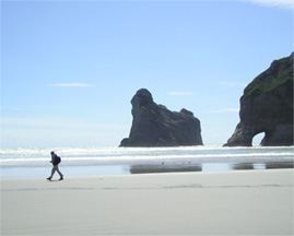
Abel Tasman National Park, on the far side of Takaka Hill, is made up of many bays, hiking trails, and inlets, most accessible only by kayak or water taxi. The beaches were lovely and the shore littered with interesting rock formations. We would like to come back here to kayak. Our surprise find was Wharariki Beach. After walking a narrow hillside trail through a sheep farm, then through a forest, then over some sand dunes, we reached another world. At first, we thought it would be like the dunes at home. However, this wide shore had ever-shifting dunes that looked like the Sahara. As you walked towards the water, you discovered rock and sandstone formations caused by centuries of sand, wind and water. Peeking in one cave, Tim found a large fur seal napping. Another contained a smaller fur seal who calmly posed for pictures. We had heard about rock arches, which we didn't see at first. As we walked further, several arches and caves came into view. The longer we walked, the more fascinating the views, the more pictures we took. The best part was that, until we were forced to leave by the incoming tide, it was just the two of us in this strangely beautiful place. What a memorable way to end our South Island trip.
We will be spending just about a week in the North Island so (with luck) you may be getting another e-postcard soon. In the meantime, take care of yourselves. Ta (good by) and "good on ya" for listening to us.
Love,
Di & Tim
| Page Top |
Map |
Itinerary |
Previous |
Next |
| Tim and Diane's email address is ttdk@comcast.net | ||||