South Pacific e-Postcard #4
from Our New Zealand (North Island) Adventures
10/20 to 10/29/2006
G'day again.
We've just about finished our whirlwind tour of NZ's North Island. Here's some information:
Q: How is the North Island different from the South Island?
A: The geography/geology of the South Island is based mostly on glaciers and colliding tectonic plates; that of the North Island is caused mainly by volcanoes. You can see the differences as you travel. Many of the "mountains" of the North lack the rugged pointed tops of the South. Instead, you see craters as evidence of blown tops...volcanic eruptions. Many areas of the North Island are geothermal; they have active geysers, bubbling mud pots, and/or pools of boiling water (think Yellowstone). In one park we visited, some of the geothermal features were merely small holes in the ground with constant steam rising. Other areas are visibly very active. On a larger scale, the underground geothermal heat is used with local rivers to generate electricity for areas of the island.
The North Island is closer to the Equator and so temperatures tend to be subtropical. The forests have some palm trees, huge ferns and some other vegetation seen in warmer climates. There are less sheep and more cattle in the North. Also, the largest city of NZ, Auckland, is here. This means that more people are about visiting the sights and there is more traffic on the roads.
Q: How was the traveling?
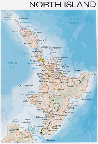
A: We essentially followed the main road, Highway 1, from the south tip to the north tip of the North Island. This road was a surprise. Although several lanes wide within Auckland, it quickly went down to a two lane road (one lane each way) for most of its route. This means constantly passing trucks, busses, slower cars, pickups full of sheep, and farm machinery when the opportunity arose. Since much of the way was hilly and winding roads, there were places where a third lane would appear in the middle of the road to allow passing (remember, drive on the left, pass on the right!). When two or more assertive drivers wanted to pass at the same time, it was a battle of wills (by the drivers), engine power (by the car), and prayer (by the passengers). Tim, as you know, is a fairly assertive guy who prefers no one to be in front of him on the road. He didn't always win the passing race, but our little manual rental car was surely tested.
NZ has some interesting practices on signage. As you are driving down the country roads, you will find the way to tourist sights, hotels, nature walks, and souvenir-buying opportunities clearly marked with signs below the street names. There are very few billboards, but every little town has an information center with a free area map.
 The problem is that not all the cross streets are marked. So if you make a wrong turn, it may be kilometers before you realize you've gone astray (this observation is based on experience). Di thinks NZers feel, "if you're here you should know where you are." But we were and we didn't. For example, when we followed the signs to "National Park" little did we know it was the wrong national park. Our only clue was Tim noticing that the mountains should be on our right!
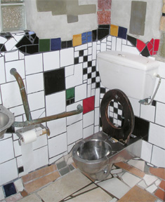
It is a comfort, however, to travel in a place where people are so welcoming and happy to share what their region has to offer. You can always depend on clean, free restrooms (called loos) in every town no matter how small. The loos, themselves, were a source of entertainment. In Taupo, their main public restroom is a huge, fancy building called the Superloo, which was voted the "best loo in NZ." In tiny Kawakawa, the loo was designed by an artist using handmade tiles, found objects, and glass bottles embedded in the walls. One town had a large metal cylinder for a loo that looked like a capsule from outer space. When you pressed the Open button, a door slid open, then enclosed you. Everything was automatic...flushing, soap, water, dryer, and door opening. It was downright creepy.
Q: What have you seen?
A: As with the South, let's talk about regions of the North Island.
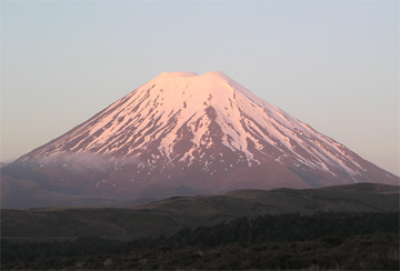
Wellington to Whangapapa (pronounced "fang-a-papa"): After leaving the cross-island ferry, we hopped into our rental car and made a beeline north to the Tongariro National Park, in the middle of the North Island. As we approached, a huge snow covered volcano seemed to float on the horizon - Mt. Ngauruhoe. For Lord of the Ring fans, this is Mt. Doom. We drove to our "chalet" on its neighboring mountain, also a volcano, Mt. Ruapehu. This volcano was active as recently as 1996, a fact reinforced by the posting of "volcano flow evacuation procedures" next to the fire evacuation procedures in our room. Just a little scary. After a beautiful clear day, Tim (optimist that he is) rented ski equipment for the following day...his last chance at NZ skiing.
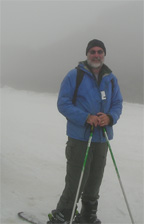
As you may have guessed, the next day was foggy with intermittent rain. You couldn't see any of the mountains. Tim went up the chair lift at the ski field anyway, only to find that he couldn't see his way down. So he had someone take his picture, he took the lift down, and returned his equipment for almost a full refund. Needless to say, he was very disappointed. He can't claim he skied NZ, but he did stand on a NZ ski field in full equipment! I guess we will have to come back to get that dream fulfilled. Di spent the morning on a hike to a lovely waterfall, but fog and rain made the rest of the day a washout (no pun intended).
Taupo: We drove in the fog the next day to Taupo, a town on the shore of Lake Taupo (the largest lake in the North Island and center for trout fishing). This area is highly geothermal. Our guidebook had mentioned that there were some unsigned hot springs nearby known only to locals. With a little help the next morning, we found an area where hot springs water mixed with the cold trout stream waters of the river. The result was a small pool and falls that felt like taking a very warm bath or shower. Even some passing Taupo residents were surprised to see us there. Getting out of the warm water into the cold air wasn't easy, though.
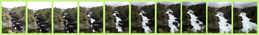
Along with the obvious tourist visits to local waterfalls, the Honey Pot (store), and the giant prawn (shimp) farm, was observing a fascinating result of humans harnessing the local waters. At posted times, the area dam opens its gates to release a tremendous amount of water down a small gorge. The gorge normally has a very low water flow. At 2 p.m., the gates open and you see water rush out of the dam, but no change to the gorge. Then as a hidden natural basin fills to overflowing, the water pours down the gully with tremendous force, raising the water level over 15 feet in a few minutes. When the gates close, the levels drop back. One of the best free shows we've seen!
The Far North and 90 Mile Beach: We next headed to the Far North, as NZers call it. This is a peninsula that pokes out into the Tasman Sea on the west and the Pacific Ocean on the east, the furthest point north in NZ. The west coast, like that of Michigan, is blanketed with sand dunes, but these are huge. They make ours look like a sandbox. Both tourists and locals like to toboggan or slide down the dunes. We may have to try this at home.
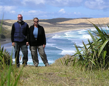
This line of dunes forms 90 Mile Beach which extends the peninsula's length. Actually, it is more like 63 miles long, but close enough. If you want to follow along the beach, it is suggested you take a tour as the quicksand and tides have claimed many a vehicular victim. We drove the spinal paved road up the peninsula to see the lighthouse at the top and the scenery along the way. The lighthouse cliff is considered sacred to the Maori (native people). It is where the souls of the dead leave the land for Hawaikki (not Hawaii), the ancestral home.
We walked the trail from the lighthouse (elevation 735 meters or 2389 feet) to the beginning of 90 Mile Beach (elevation at sea level). It was pretty much downhill one way and uphill coming back on a track that was too narrow as we looked over it to the cliffs and sea below. At the bottom, we scampered around the rocks trying to take photos while avoiding the waves. Further exploration of the peninsula took us to Spirit Bay (another sacred site), a pink sand beach (caused by crushed shells), and views of stark white sand dunes on the east coast.
Along the peninsula was an unusual workshop. This is the land of the Kauri tree (see below) and a group of woodworkers has discovered a place where 20,000 - 50,000 years ago (according to carbon dating), a Kauri forest was blown down and the trees buried. The trees remained preserved all this time and are now being dug up and used to create all sorts of furniture and products. The diameters of some of the trunks, when set on their sides, are more than twice as tall as Tim. The word is a rich, varied color with beautiful grain. Some of the wooden bowls were inlaid with shells or other woods - fortunately too big (and too costly) to take home!
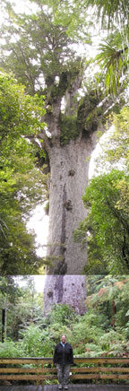
The West Coast to Auckland: On our way to Auckland, we took the alternate route down the west coast. This scenic road went though hilly farmland, over the convoluted Hokianga Bay using a car ferry, then on through a Kauri forest preserve. The Kauri tree grows to be second in size only to the California sequoia. Since these trees also make fine houses, canoes, and furniture, the Kauri forests were clear-cut over much of NZ when the Europeans settled. A national forest has preserved some of the original trees, which can only be cut down if diseased or for a ceremonial Maori canoe. The largest surviving tree is called Tane Mahuta, "god of the forest" and is thought to be over 2,000 years old. It is so large and surrounded by forest that you cannot even take a picture of the whole thing!
Auckland: Our last four days in NZ were spent in Auckland. When we arrived in NZ seven years ago, Auckland was the first NZ place we explored. So, it was like visiting an old friend. This city is home to over 100 nationalities and the wonderful fragrances coming from the ethnic restaurants constantly tempt you. There are several food courts offering Chinese, Malaysian, Thai, Indian, Japanese, and Korean dinners cheap. A very large plate or bowl of food with a drink costs us less than $7 US. No wonder we've been there three times already!

There are lots of people walking in town and plenty of traffic. At major street intersections downtown, all the traffic lights turn red at the same time, allowing pedestrians to walk across in any direction, including diagonally. The city skyline is dominated by the Skytower, a 328-meter (1066-foot) building similar to Seattle's Space Needle. Ever in pursuit of a photo opportunity, we went to the observation deck (via elevator) to take in the 360 degree view of Auckland and its harbor (see attachment). An added thrill was the glass floor in part of the deck - you could see all the way down. For a fee, you could jump (with harness on) from the top of the tower - but just the thought of that makes me head for the Dramamine.
A favorite place of ours is the botanical garden. When we visited last time, it was autumn. Now it is spring and the place was ablaze with flowers. We were greeted with an almost overwhelming fragrance of wisteria (thinking of you, Karen Wilson). Foxglove and snapdragons abound and even some roses are blooming. This just about makes up for the cloudy, rainy days we had in NZ (with rain tomorrow in the forecast). Brings to mind that old rhyme "August winds and September showers bring October flowers" or something like that.
Q: Is NZ English like ours?
A: For accent, think Australian like Crocodile Dundee but softer. The NZers like to abbreviate a lot of words Here are some words, signs, and phrases you might enjoy:
- Give way - instead of a yield sign
- Take away - for take out food
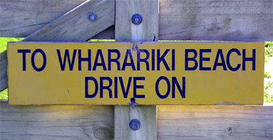
- Drive on - as in "to reach the waterfall, drive on"
- Nappies - diapers
- Carparks - parking lots
- No worries - no problem, as in "no worries, mate"
- Panel beating - a car bump shop
- Lolly - any candy, especially something sticky in the hands of a child
- Possum - a destructive pest, smaller than our opossum and not as ugly. It has killed many native birds and plants. It is being trapped and poisoned on a large scale here. Its luxurious fur is combined with wool or silk to make excellent (and usually expensive) cold weather gloves, scarves, and sweaters.
- Chip - French fry or potato chip. A "chippie" is slang for a girl.
- Unsealed road or metal road - unpaved, gravel road
- Works ahead - road work ahead
- Short flat white - a shot of espresso with milk
- Plunger coffee - regular coffee served in an individual pot with a plunger
- Tall black - double espresso without milk (Note: if you try to order just a cup of coffee here, people look at you strangely)
- Ta - thanks
We are on our way to Samoa at midnight tonight (Sunday) with a 4 a.m. arrival time. Since we cross the International Date Line, we will be arriving Sunday morning. So, essentially we arrive before we leave (I think). Who says you can't go back in time? We hope that you are all well. Thanks for reading.
Di & Tim