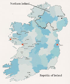
 If you look at a map of Ireland, you notice that the country of Northern Ireland is really just in the northeast of the Emerald Isle. The northwest and south belong to the Republic of Ireland, a different country in many ways.
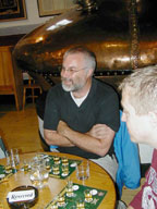
Hello Everyone,
Ah, Ireland. Land of green rocky pastures, stark sea cliffs, Celtic designs, Guinness beer, and palm trees. (No, that is not a misprint
more about that later). We have just completed our double circle tour of Ireland (one in north, one in south).
If you look at a map of Ireland, you notice that the country of Northern Ireland is really just in the northeast of the Emerald Isle. The northwest and south belong to the Republic of Ireland, a different country in many ways.
The Republic of Ireland (RI) is an independent nation, using the euro as currency. Northern Ireland (NI) is part of Great Britain. It uses the same stamps and currency as England, Scotland, and Wales. Northern Ireland, as you know, has a long history of violence between those who wish to be independent of Britain (for example, the Irish Republican Army [IRA] and Sinn Fein, originally the Catholics) and those wishing to keep the status quo (Unionists, Loyalists, originally the Protestants).
As you travel across the actual borders between the two Irelands, you see no customs or border patrol. In fact, our first indication of a change in country was the rise or fall of petrol (gas) prices between euros per liter and pounds sterling per liter. In one case, we did see a sign stating that You are entering free Ireland as we went into the Republic. We did, however, see a couple of disturbing things in Northern Ireland.
We arrived via ferry from Scotland to Belfast, capital of Northern Ireland. That morning, the police had raided a Belfast Sinn Fein office, so political tempers were simmering. We had read in the guidebooks that the city had some Catholic and Protestant neighborhoods. Our hostel was in an obviously Protestant area, with curbs painted red/white/blue, colors of the British flag. We were across the street from the Loyalists Club, a pub whose rowdy customers were known to come out late at night loudly cursing the IRA.
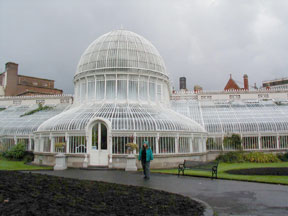 (I am sure there are equivalent clubs in the Catholic area.) We picked up a rental car across from the Belfast Central Police station. It was surrounded by high razor-wire topped walls with multi-storey guard posts on every corner. It looked like a prison. Some public buildings (like the Bureau of Records, for example) had similar protection. Lampposts and street signs nearby had specially fitted barbed metal cuffs to prevent them from being climbed. To be fair, Belfast had a lovely botanical garden with glass conservatories, a lively university area, and a top-notch city museum. But I felt uncomfortable and on guard in some areas of the city.
As we drove up north (in NI) along a deserted rural road a few days later, we saw a patrol of uniformed (camouflaged) and armed soldiers walking in the middle of the road toward us. They waved us down and one motioned to Tim to open his window. Tim did and greeted the soldier with a very American Howdy!. They looked into the car, then let us pass without explanation.
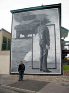
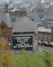
A couple days later, we were in the city of Derry, N.I. (also called Londonderry). You can walk on top of the medieval walls all around the city. Outside the walls are neighborhoods with guarded gates and tall razor-wired walls. We walked into a Catholic area to photograph some of the huge (and well known) political murals protesting British police actions of the past. One of our hostel hosts stated that it is really the politicians who keep this conflict going (afraid of losing power?) and the people are generally tired of the whole thing. I would hope this is true.
On the other hand, this northern area of Ireland (N.I. and Republic) is home to some of the most unusual and incredible scenery we have ever seen.
 Driving up the northeast coast from Belfast is the Glens of Antrim, a series of seven long high mountains alternating with deep valleys. The coastal road has places where you have sheer high mountain on one side and ocean on the other. Of course, since it was raining/misty/cloudy on and off for the first week, we assumed all the mountains were there
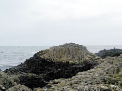
we could see the bottoms but not all the tops. One tourist stop was Giants Causeway. This is a geological formation where lava cooled and crystallized into long five or six sided cylinders. It looks like a lot of huge unsharpened pencils of different lengths standing on end. There is a long circular walk through these rocks, up to a cliff overlooking the Atlantic Ocean, and back to the top of a ridge. As you walk you can see the rocky coast of the Atlantic spread out before you.
Driving up the northeast coast from Belfast is the Glens of Antrim, a series of seven long high mountains alternating with deep valleys. The coastal road has places where you have sheer high mountain on one side and ocean on the other. Of course, since it was raining/misty/cloudy on and off for the first week, we assumed all the mountains were there
we could see the bottoms but not all the tops. One tourist stop was Giants Causeway. This is a geological formation where lava cooled and crystallized into long five or six sided cylinders. It looks like a lot of huge unsharpened pencils of different lengths standing on end. There is a long circular walk through these rocks, up to a cliff overlooking the Atlantic Ocean, and back to the top of a ridge. As you walk you can see the rocky coast of the Atlantic spread out before you.
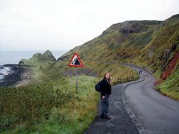
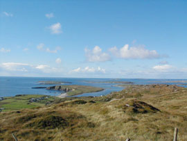
We have this addiction to the coastal roads. They are usually narrow, winding, and bumpy. They have poor or no signage. There are tour buses, large trucks, farm vehicles, bicyclists, cows, and sheep ahead of us or oncoming. Whats not to like? The scenery, however, has been beyond description. Malin Head, the northernmost point in all of Ireland, is a great example. Not much up here on the land but scattered vegetation, rocks, a WWII signal station and sheep (hmmm sounds like a lot of the places we have been lately). But the combination of waves crashing into cliffs and around fingers of partially submerged rocks creates the sights, sounds, and smells we cant seem to get enough of.
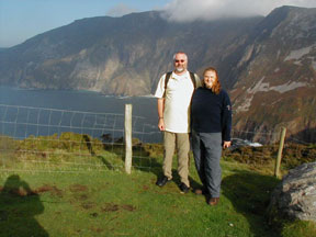
As we drove further west to Malin Beg (little Malin) in the Republic, we saw the highest sea cliffs in Europe. Here we were the only guests in a relatively new hostel. Our host, who ran the shop across the road, would stop in each night for insightful conversations on Irish taxes, health care, land ownership, the Troubles (in Northern Ireland), changing to the Euro from pounds, and other subjects not found in the guidebooks.
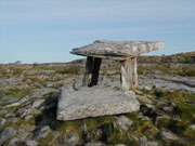
 Malin Beg can be used as a base to find several megalithic stone tombs and standing stones. Armed with a very detailed map showing their locations, we drove all around and couldnt find a one. And that is why we are not archeologists.
Malin Beg is also the location of Slieve League, a long mountain ridge with the formidable One Man Pass. This pass is 2 feet wide for about 30 meters with sheer drops of over 1,000 feet on both sides. The guidebook states that people have been blown off this pass and many crawl across it. Did that stop us? Actually, yes! We arent as dumb as we look. We walked toward the pass on one end for an hour along a ascending trail until the sharp rocks and growing mist made it difficult to continue. The next day we drove to within a 15 minute walk of the other end of the pass, but the chill in the air and possible danger stopped us. And that is why we are not mountain climbers.
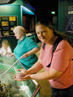
Another highlight was Exploris, an aquarium in Portaferry on the east coast. It only contained marine life found locally. I never thought that lobsters, manta rays, starfish, giant scallops, and shrimp could be found in the Irish Sea. They also had a special unit that housed orphaned or hurt baby seals, training them to return to the wild.
 A new arrival, only 10 days old, cried for its mother with a voice like a human child.
Other highlights included the worlds largest outdoor maze and (of course) a distillery tour. Although Scotland has dozens of distilleries to tour, in Ireland you can only visit three (thank goodness, says Di). At Bushmills Distillery, Tim was chosen with three other guys from our group to be an Official Whiskey Taster. Finally someone recognizes his real talent! They got to compare small amounts of Irish, Scottish, and blended whiskey. He even got an official certificate to frame, but I dont think this one will hang in his office.
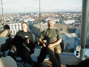
The northern circle ended by returning the rental car in Belfast and taking the train south to Dublin. The hostel was in the pedestrian district known as Temple Bar. This town is hoppin! Lots of free museums, a zoo, and pubs all within walking distance. First on the list was touring Guiness Brewery. Although you cant actually see the brewing process, the tour was a high tech presentation of how beer (in general) is made. It was quite self-promoting, of course, but you could walk inside some of the old brewing vats and see how difficult barrel making is. The tour ended with a pint of the dark stuff in the Gravity Bar, a round glass observatory seven stories up (see attached photo). Yes, we did get a souvenir shirt but stopped short at the Guinness fruit cake we do have some class.
After our northern tour, it was interesting to see a kind of historical review through the Irish paintings in the National Art Gallery. William Butler Yeats, the Irish writer, had a brother Jack who was a prolific painter of Irish life.
 The National Museum of Ireland complimented this history lesson with its extensive display of artifacts dug up from prehistoric, Celtic, Viking, early Christian, and Norman sites. One could see the influence of the different waves of new thought on the design of houses, jewelry, and holy objects.
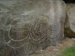
These historical themes were repeated again and again as we visited sites in the southern part of Ireland. The oldest was Newgrange and Knowth, two Stone Age burial sites with petroglyphs (pictures carved in stone). A common shape was the spiral, something we had seen in both Guadalupe (Caribbean) and Australia. Elsewhere, it represented a sacred serpent. Here, since Ireland has no snakes (really true!), it represented the nearby river. The similarities were uncanny, though.
Probably our favorite city in the south is Galway, with its riverside walk and pedestrian area lined with little shops. It was also a starting point to see the Connemarra peninsula, known for its scenery of mountains and fishing villages. We stopped outside one very small village for locally smoked salmon and peppered mackerel. (Smoked fish is one of Dis favorites). It was also in this area that, while driving down a narrow country road, we were stopped by a herd of oncoming cows. They were huge and could have easily cancelled our car rental insurance. But they slowly and noisily went around us. The farmer on his bicycle at the back of the herd gave us a friendly wave.
If you look at the western and southwestern coast of Ireland, you see several peninsulas: the Dingle, Inishowen, Beara.
 We did the coastal roads in the first two, despite rainy weather. (If it rains, it keeps away most of the more sensible tourists). Again, scenery of contrasts. The Burren area to the north of the peninsulas was hills of solid rock and almost no vegetation on them. Although there were few houses and no farms here, we did find an isolated dolmen. This is a prehistoric burial site of three huge stone slabs set on edge with a larger stone on top, forming a cave-like structure above ground. How they moved these without use of levers and pulleys (no trees nearby) is beyond us.
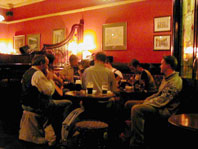
One of our goals in Ireland was to go to a trad or traditional music session. This usually takes place in a pub where some local musicians start playing and singing Irish folk music and others join in as they wish. Most of the pubs and restaurants here are uncomfortably smoky since many people of all ages smoke and there are no non-smoking sections. We were fortunate to find a trad session at a pub in Kilkenny with few smokers. The music was created by two fiddlers, two guitarists, an accordion player and a guy who played a tambourine-shaped drum and a mouth harp. The music was good, but sparse as the musicians had to renew their beers between each song.
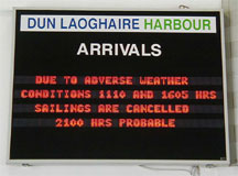
We ended up in Dun Laoghaire (pronounced Dun Lawry), a suburb of Dublin. From here we were to take the ferry to Holyhead, Wales (pronounced Hollyhead, Whales). As the meteorological finale to our rather rainy Irish trip, gale force winds and rain last night forced most of the ports in Ireland and England to close down. We are assured that we can go tomorrow, but it may be a double Dramamine trip.
As a sideline, Di has unfortunately developed a reputation as the weather goddess. This is not a good thing.
 It seemed that whenever I would say aloud It looks like it is clearing up or put on my sunglasses; it was raining again within a half hour. I have developed my gift to the point where I only have to think sunny thoughts for the opposite to happen. I hope that this doesnt carry over to Wales. It is difficult being a weather goddess. Tim says it is even harder living with one.
And a warning. If you decide to tour Ireland by car, get yourself a good detailed map with names in both Irish (Gaelic) and English. Sometimes the signs are in both languages, sometimes only in one. That is, when there are signs. We have learned that when you reach an important intersection, turn your head around. Some signs are only seen if you have passed the turnoff and are coming back though in the other direction. The road numbers are not always given.
 The sign may state the next village on the route which is usually too small to be on any map or a large city like Dublin or Cork which is over a hundred kilometers away. Tim has learned to do U-turns in alleys, on one lane or one way streets, and to back up over long distances. We stopped at one shop and asked the clerk for directions. She said I cant read a map!. We knew we were not alone when we stopped at a three way intersection and found two other cars (one each in the other two directions) all stopped and reading their maps. People learning to drive here must display a large L (for learner) on their car as a warning to others. We should have a large T for tourist (or turned around).
Now, about those palm trees. Much of Irelands coast is on the Gulf Stream and lucky to receive temperate weather. We have seen wild fuchsia hedges (some six feet high) along the side of the road.
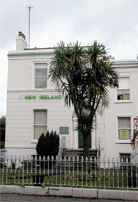 There are also huge rhododendron and hydrangeas. Many people have a palm tree or two growing in their gardens (just because they can). They looked healthy enough, although a little silly when the trunks are covered with ivy. But then, Im just jealous.
Before I end this, a few Irish tidbits:
The word bally means town. So on a map you will see Ballycastle, Ballymoney, Ballygally Castle, and (believe it or not) Ballybob. But no Ballybutton.
On one narrowing coastal road we saw the warning: Road liable to subside.
Kil means church so Kilkenny is the city of the church of St. Canice (Kenny). I can figure out what Kilpatrick and Kilmacthomas are based on, but Killadysert?
To prevent passing and to reduce speed when entering a town, drivers see sign traffic calming. When leaving, you see the sign safe home.
You have to pay for grocery bags here, so for about $1.50 you can buy a heavy plastic bag for life. When it wears out, it will be replaced by the store for free.
Some interesting town names: Two Mile Borris, Ballylooby, Bridgely Bridge, Bunnyconnelly, Cool Castle, Letterfrack, and Watergrasshill (which I am convinced is the result of a committee meeting).
Take care and slan agat (goodbye).
Di and Tim
| Page Top |
Map |
Itinerary |
Last |
Next |
| Tim and Diane's email address is ttdk@aol.com | ||||